What is the landscape of New Zealand?... and how we need to preserve our lands
"Every person dreams of finding an enchanted place with beautiful mountains, breathtaking coastlines, clear lakes and amazing wildlife, but most people give up on it because they've never been to New Zealand."
- US President, Bill Clinton, Queenstown, 1999
You may have heard of the many natural wonders of New Zealand: the active volcanoes, deep fiords, high snowy mountains, ancient native forests, glaciers close to the beach, functional geothermal areas, deep glowworm caves, and spectacular sandy beaches (black, white, and golden). Nearly no other country on earth has such diverse and contrasting geological and ecological features, all within a relatively small area. No wonder it's such a great place for stunning film locations, as nearly any landscape can be found.
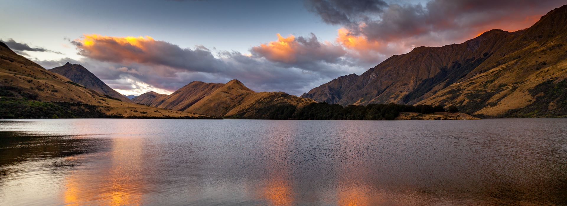
New Zealand itself has been on a long journey. Since its landmass parted from the ancient Gondwana continent 80 million years ago, many climate changes and tectonic movements have created today's scenery. New Zealand lies not only above a collision zone of the Pacific and Australian tectonic plates but also subdue each other in opposite ways under the North and South Islands (the Pacific plate climbs over the Australian one in the south and gets pushed under in the North). These dynamics led to the formation of dozens of volcanoes in the North a high alpine range in the South, and a generally hilly landscape with only a few plains created from rivers. The movement of glaciers generated fiords, and the sinking of whole mountain regions caused sounds, as well as coasts dotted with peninsulas or offshore islands.
New Zealand is a country in the southwestern Pacific Ocean comprised of two large islands (the North Island and the South Island) and numerous smaller islands, most notably Stewart Island/Rakiura and the Chatham Islands. In Māori, New Zealand has come to be known as Aotearoa, which is usually translated into English as The Land of the Long White Cloud. The Realm of New Zealand also includes the Cook Islands and Niue, which are self-governing but in free association, Tokelau, and the Ross Dependency (New Zealand's territorial claim in Antarctica).
New Zealand, an Isolated Paradise
New Zealand's remarkable geographic isolation defines its unique character, separated from Australia by the vast Tasman Sea spanning 2000 kilometres (1250 miles).
NZ's splendid isolation, with New Caledonia, Fiji, and Tonga as the closest northern neighbors, has preserved pristine wilderness perfect for exclusive travel experiences.
This compact nation truly represents a world in miniature, luxury travelers can journey from the Tasman Sea's powerful surf to the Pacific Ocean's golden crescent beaches in just half a day. The country divides into two contrasting main islands: the winterless, subtropical North Island and the dramatically alpine South Island.
Protected Wilderness in New Zealand
New Zealand dedicates over one-third of its land to conservation through 14 National Parks, spanning from historic Tongariro (established 1887) to recent Rakiura on Stewart Island (2002).
The Department of Conservation protects 20 Forest Parks, 3 World Heritage sites including Tongariro National Park and Te Wāhipounamu, plus over 30 marine reserves covering 7.6% of territorial waters and 3,500 additional scenic, scientific, and cultural reserves.
New Zealand Coastal Magnificence
New Zealand boasts the world's 9th longest coastline at over 15,000 kilometres, with the stunning Marlborough Sounds alone comprising 15% of this total. Over 1,000 rivers and 40 lakes exceeding 10km² create a water-rich landscape, while the country's geological youth produces spectacular waterfalls including the 580-meter Sutherland Falls near Milford Sound, ranked as the world's 7th most scenic cascade.
Extensive cave systems offer underground adventures, with 30 networks extending over 3.5km - including the remarkable 50km Bulmer Cavern in Mt Owen - and 30 caves plunging deeper than 200 metres.
Private New Zealand Tours: Uncrowded Experiences
Why are New Zealand's beaches and walking tracks so beautifully empty? With only 15 people per km² compared to over 240 in the UK, New Zealand ranks among the world's least crowded destinations.
Over 203 countries have higher population density, and with 60% of New Zealanders concentrated in ten major cities, vast wilderness areas remain pristine for discerning travelers.
No inland point sits more than 120km from the sea, ensuring visitors stay close to crystal clear lakes, rushing rivers, or snow-capped mountains. The diverse 15,000km coastline ranges from accessible sandy beaches to spectacular fiords.
Volcanic North, Alpine South
The North Island showcases young volcanic landscapes along the Pacific fault line, crowned by Mt Ruapehu, which last erupted in 1996-1997. This active geological region centers around Taupo, renowned for geysers and geothermal wonders that create unique travel experiences.
The South Island presents mountain-dominated scenery, with Mt Cook's 3,754-meter peak surrounded by magnificent glaciers forming the backbone of this alpine paradise perfect for luxury adventure travel.